Broad Tails and Sharp Shins

I was looking out the window at work yesterday. I spotted a female Broad-tailed Hummingbird fly into a ponderosa pine and land in a nest. I meant to bring my camera to work today, but forgot. I borrowed a much better camera and took several photos. This is the best, although I had to angle through a window so it’s not terribly sharp.

The nest is made of spider webs and gossamer (which is just another word for fine spider webs). The hummingbird then covers the outside with lichen, moss, and bits of tree bark to hide it. I think this one is still sitting on eggs. When the young hatch and grow, the nest actually expands until it looks more like a dish.

19402037_10212397074017423_7358713338290714630_o

As I was walking away, I heard a bit of a commotion behind me. I turned and saw the resident Sharp-shinned Hawk perched on the railing about 20 feet away.

19390598_10212397073937421_3856109806706230991_o

It stayed about 10 seconds. I happened to take a photos just as it took off.

19417366_10212397073977422_3548759465085245310_o

Posted in Birds | Comments Off on Broad Tails and Sharp Shins

Bird #481 — MacGillivray’s Warbler

oporornis (from opora, autumnal, and ornis, bird) tolmiei (in honor of William Fraser Tolmie, friend of John Kirk Townsend) — MacGillivray’s Warbler was named by John James Audubon for his friend and editor, Dr. W. MacGillivray.

Saturday, June 17, 2017 — 11:20 pm

Eagle Peak Trail — Pike National Forest, Colorado

I was carefully hiking down the steep slope of Eagle Peak. My friend, who had encouraged and guided me on the hard climb up, was about 50 yards ahead of me. We passed through a grove of aspen and were making our way down along Goat Camp Creek. I heard a singing bird and knew it was a warbler. I also knew that the habitat — thick brush along water — was potentially good for MacGillivray’s Warbler.

IMG_8103

MacGillivray’s is the only wide-ranging North American warbler that I’ve never seen. And I didn’t mind the excuse to take a break. I listened to the song a couple times, then pulled out my phone and found the song of the MacGillivray’s Warbler. It was a match.

But as soon as I began playing the song on my phone, the real bird stopped singing. I repeated the recording several times and saw a small bird flit into the lower branches of a bush about 20 feet away. I didn’t have my binoculars or good camera, but I could clearly see that it had a yellow belly, gray hood, black chest, and white eye ring. I had my bird.

IMG_8104

As I looked, it took off and flew right at me, passing within inches of my head. I saw it briefly in a second bush along the creek. Then it flew to a branch in an evergreen right above my head. I took several photos with my phone, but they just show a back-lit tangle, and I can’t find anything in them that looks like a bird.

My friend was waiting patiently, and I didn’t want to disturb the bird any longer. I put my phone away and continued down the trail.

Posted in Birds | Comments Off on Bird #481 — MacGillivray’s Warbler

Eagle Peak

Eagle Peak is one of the more notable mountains along the Rampart Range west of Colorado Springs. It rises like a pyramid behind the Air Force Academy, with a bare rock face that stands out among the other tree-covered mountains. A friend encouraged me to climb it with her on a warm Saturday morning.

We drove in through the north gate of the Academy with no issue — we just had to show our drivers’ licenses. We parked in the lot for the visitor center. Here’s what the peak looked like from there.

IMG_8085

We hiked up a dirt road for about a quarter mile to the trail head, then cut off into the woods. We followed Goat Camp Creek, a small stream that could be heard more often than seen.

IMG_8093

This was the most impressive view of the stream.

IMG_8094

The trail was steep and uneven. I had to clamber over rocks and tree roots in many places. I had the same issues as when I climbed Mount Herman — I felt fine but frequently got dizzy. About half the way up, the trail flattened out for several hundred yards through an aspen grove.

IMG_8095

The path then climbed steeply through a long patch of scree. The surface was loose gravel on which it was hard to get a solid footing. There were rocks scattered throughout, some of which were firmly planted and some of which moved. I caught a bit of a second wind on this stretch and made my best speed of the day. Something unbelievable happened along about here — we caught up with and passed two other hikers.

IMG_8090

For the final hundred yards to the summit, we were bouldering. The blue dots mark the trail, such as it is.

IMG_8088

The view from the top was amazing. Pikes Peak stood out to the west. The altitude at the summit of Eagle Peak is 9,368 feet, a climb of 2,128 feet in just over a mile.

IMG_8100

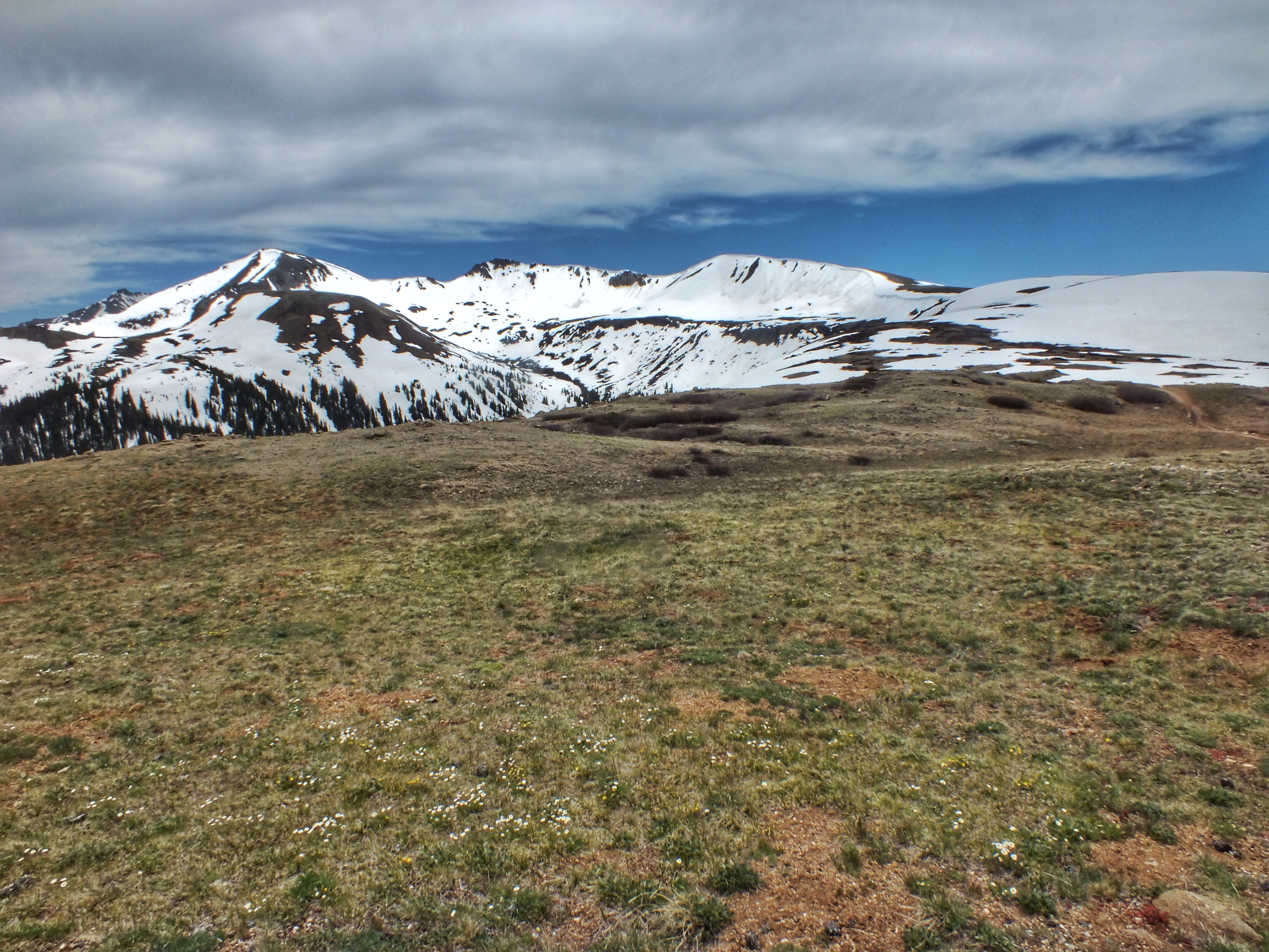
We could see a lot of other high peaks way off to the north.

IMG_8101

Looking south toward downtown Colorado Springs.

IMG_8098

The view to the east was the most impressive, with the Air Force Academy spread out below.

IMG_8099

IMG_8097

We stayed on top for maybe 15 minutes. The sun was intense, but a brisk wind kept things pleasant.

Going down wasn’t as tiring, but it was harder going. I slipped several times on the steep, loose gravel and only just kept from wiping out.

IMG_8102

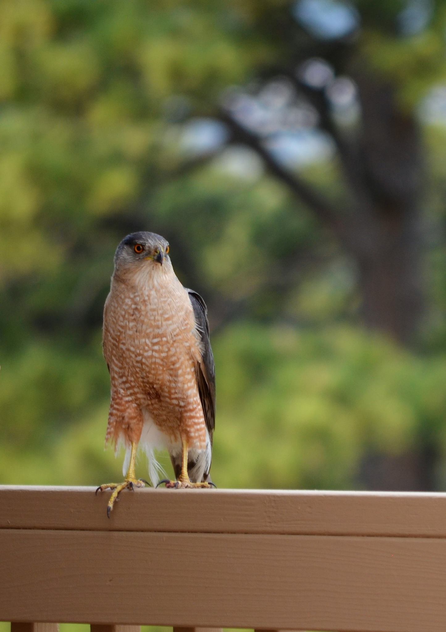
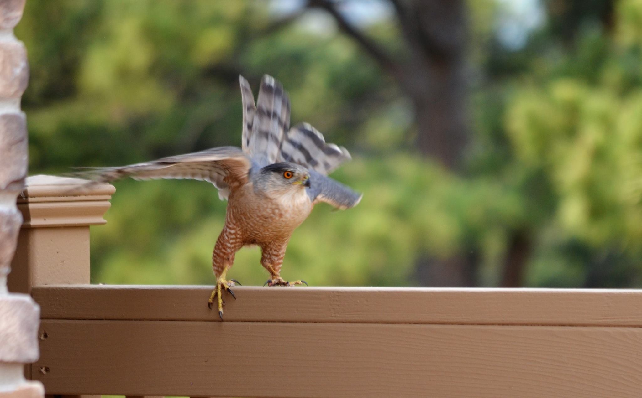
On the way down, I spotted a lifer, a MacGillivray’s Warbler (next post).

About where I saw the bird, my friend insisted on taking a photo of me. The fact that I look like an old man on crutches isn’t just a pose.

IMG_8086

The hike wiped me out. It was close to 90° once we got out of the breeze on top. I had two bottles of water, which weren’t nearly enough. I had to take a seat on a rock for a couple minutes not long after this photo was taken because I was feeling light-headed and came close to taking a header on a rock.

When I got home, I looked up Eagle Peak Trail on the internet. Here are a few of the comments I found.

  • It is a tough climb, along a pretty rugged trail.
  • Quite a work out, but views make it totally worth it. Only gave it 4 stars because of how hard it was on the knees on the way down (loose gravel, steep grades).
  • The trail to the top could rival the Manitou Incline, gaining 2,000 feet of elevation in 1.25 miles. It is steep and eroding and needs work.
  • Eagle Peak isn’t the highest mountain in the Pikes Peak region, but this trail is so steep and unrelenting it may feel like it — with a grade that can rival the Manitou Incline in steepness. But at least that has railroad ties. The trail surface on Eagle Peak is loose gravel that can challenge even the most sure-footed hikers on the descent.

After reading all that, I didn’t feel so bad about my slow, stumbling pace.

Posted in Hikes, Scenery | Comments Off on Eagle Peak

Independence Pass

Route 82 east of Aspen is a narrow blacktop that winds up into the mountains along the Roaring Fork River. In places, the river and canyon walls squeeze the road down to a lane and a half. Every place next to the road that was barely wide enough was filled with parked cars and trucks. We managed to find places to park a couple times and got out to look around.

IMG_7984

IMG_7985

IMG_8006

There was still quite a bit of snow in the woods and above timberline.

IMG_8034

The parking lot at the Continental Divide was packed. I managed to find a spot next to the outhouses. The thing most people seemed to be fascinated by was the snow. We had to wait a couple minutes to get this photo by the sign because an oblivious couple were taking photos behind the sign of each other standing in the snow. They made no effort to get the sign itself or any of the amazing views in the photos. They just wanted the snow.

IMG_8026

We hiked a short trail up over the tundra.

IMG_8005

IMG_8004

The mountain in the middle of this shot is a 14er, but I forget which one.

IMG_8003

Here’s a close-up of the same mountain. We were at 12,095 feet, so the summit was still another 2,000+ feet above us.

IMG_8025

I was hoping to scare up a White-tailed Ptarmigan or a Brown-capped Rosy Finch, but with the crowds, I didn’t figure I had much of a chance. As it turned out, I was right. All I saw were several White-crowned Sparrows, a Common Raven, and a Horned Lark.

IMG_8035

IMG_8036

IMG_8002

The road down the other side was just as beautiful, if somewhat less harrowing.

IMG_8037

At the bottom, we happened upon Twin Lakes. I pulled into a day-use area and passed an empty fee station. It was in sad shape and looked like it hadn’t been manned in years. We got out and walked around for maybe 15 minutes. My wife decided right off that this was her new favorite place in Colorado.

IMG_8029

IMG_8038

I heard an unusual bird song and tracked it down. I misidentified it as a Vesper Sparrow, even though the song bothered me. I took a short video and figured out back at the house that it was a Brewer’s Sparrow. In my defense, I’d last seen one in 1984 in Arizona.

IMG_8030

When we pulled out, there was a guy in the fee station. He looked at me as I passed, and I just smiled and waved. We still had the Rifle Falls State Park sticker on our windshield. That may have saved us.

I would very much like to visit Independence Pass on a weekday when the crowds are elsewhere, but even busy, it was a beautiful stretch of road.

Posted in Road Trips, Scenery | Comments Off on Independence Pass

Rifle Falls State Park

We spent the night at a Comfort Inn in Rifle. The town, located on the Colorado River, got its name because somebody at some distant point in the past, left, or found, a rifle leaning against a tree. I guess it had to be called something.

In the morning, we drove north on a narrow blacktop road through a valley full of beautiful farms. This is one thing I’m finding amazing about Colorado. Drive for miles through dry scrub and suddenly you’ll come across a patch of lush farmland along some tiny creek. There will be farms and crops and livestock. And then you’ll go around a bend and be back in the scrub. It all has to do with elevation and water, I know, but the differences can be startling.

Rifle Falls State Park is tiny, and most of it is taken up by a campground. We arrived early and most of the campers had not yet begun to stir. We paid our $7, parked in the tiny day-use lot and walked a quarter mile to the falls. See what I mean about patches of lushness?

IMG_7959

After admiring the falls for a while, I discovered a trail that led along the cliffs to the right. The rocks were full of holes and crevices, many of them amounting to caves.

IMG_7968

IMG_7969

The trail climbed gently up behind the rocks, and we soon discovered two ponds. I know there’s a state fish hatchery nearby, and I’m thinking these ponds are, or were, part of it. There were two guys fishing in one of them.

IMG_7970

The trail led to the top of the falls. There were metal platforms that stuck out from the edge of the cliffs so we could look straight down at the water or out over the valley.

IMG_7971

That’s when I discovered the secret to the falls.

IMG_7972

I believe there really were falls here historically, but for whatever reason, they are now being enhanced. The trail curved down below the falls again. Campers and other day-users were arriving, and it was getting busy by the falls.

IMG_7973

We hung around for a couple minutes and enjoyed the cool breezes in the shade that contrasted sharply with the hot sun.

I found an American Dipper in East Rifle Creek.

IMG_7990

Neither the falls or the park are worth a long trip, but if you’re in the area, it’s worth the 11-mile drive off I-70 to spend a pleasant hour or so.

Posted in Birds, Scenery | Comments Off on Rifle Falls State Park